As we drove north on Hwy A1A past hundreds of ocean viewing homes. Each bravely facing the now peaceful Atlantic Ocean, where some have battled the annual hurricane season bravely and some are just beginning their life of annual siege. Gradually, in the distance, we began to see what was once a beacon of warning to seafaring ships, but still standing tall today, it serves as a welcoming beacon, beckoning all within its towering view to come closer. It calls out to come view a city that has existed since shortly after Columbus' last voyage of discovery, plunder and enslavement. Come see a city that has been burned to the ground three times in failed attempts to drive away its then current occupants.
Turning west from our northward travels we cross the Matanzas Inlet spanning draw bridge, anticipating our entrance to the historically significant St. Augustine, the undefeated city.
Cresting and descending the western side of the massive draw bridge, we are awestruck by the quaintness of this now touristy city. And we ask ourselves, "Are we in Victoria, BC? Boston, MA? Pretoria, SA?
But after a 30 minute attempt at negotiating a large rig through streets made for horse and buggy (that were definitely not designed by Brigham Young, who designed Salt Lake City's streets so a full team of horses drawing a full cargo wagon could turn around in any street) in order to find parking for our too tall, too long and too wide rig, then beginning our walk towards our destination...... Wayne finds satisfaction in proving where we are!!!!

Our plan for this town is to explore the oldest still standing fort in the continental United States. Castillo de San Marcos. After years of reading about it and several years of teaching sixth grade social studies about Central and South America colonization and several more years teaching U.S. history in 5th grade, it has been a dream of Wayne's to walk the ramparts and gaze seaward from its bastions of this oft bombed, but never destroyed or defeated fort. Behind Ann you can see its ingenious moat that was never filled with water, but instead was used for storing livestock while under siege.
The walls, constructed of limestone coquina, quarried from the island across the bay, provided cannon ball absorbing walls.
It is composed of billions of tiny sea shells that have not completed the process of turning into limestone.
The one and only entrance or exit crosses two draw bridges across the moat that was mostly used for housing livestock, but in time of attack, if needed could be flooded by gates being opened to allow sea water to fill them.
Ann stands guard at the final entrance point to the fort.
It was a hot day, but the inner court or parade grounds was actually quite cool as we explored the many rooms of the lower portion of the fort.
The rooms were solid and used as quarters, storage, prisons, school rooms and a chapel during it's occupation by the Spanish, British and finally Americans. Can you see Grandma in the back?
There were many many cannon used here and many were still on display for us.
After a partial exploration of the lower section and a very informative Ranger led tour, we ascended the stairs to the ramparts that once were ramps for taking cannons up and down.
From the top we had an excellent view of the Plaza de Armas and some of the rooms we had visited below.
Prominently, flies the Spanish flag of the era when they colonized and defended the Florida territory.
Gazing seaward from the east facing rampart we absorb the view so many school children have seen in textbooks though their 5th and 6th grade social studies lessons. Only our view today is minus all the English warship attempting to drive the Spanish from their stronghold.
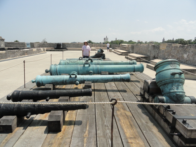
Cannons, cannons and more cannons!!
Below, you can see the shot furnace where the cannonballs were heated red hot before being shot at the attacking wooden ships with hopes of catching them on fire.
From a guard post on the southeast facing corner bastion, we see more cannon lined up for display.
And even more cannon being guarded by Grandma.
Here we are with our backs to the northeast facing bastion.
Finally, we leave the fort, walk back to our rig parked in a vacant parking lot of a defunct Firestone tire store, eat lunch and then continue our journey towards Georgia, first heading east across the Tolomato Inlet bridge to the town of Vilano Beach and our friendly Hwy A1A.
Looking southeast to the town of Vilano Beach.....
... and then backwards we see our light hose saying goodbye and inviting us to return again someday. Now.... on to Woodbine,GA!


No comments:
Post a Comment